Sunday, March 22, 2020

Adventures in Sunshine and Social Distancing

Yesterday's blue skies inspired me to seek out some mountain views. To find them, I visited the Big Four Ice Caves area, just up the closed section of the Mountain Loop Highway. The bridge over the South Fork Stillaguamish River has been removed, rendering the final section of trail inaccessible, but there is plenty of good scenery in the vicinity of the picnic area and the river. I've had success with this area as a late-winter destination in the past.

Inspired by my quiet days on the Baker River and Skookum Flats hikes recently, I also hoped for another photography outing that would conform to social-distancing guidelines. Although the morning was very quiet, I saw increasing numbers of people in the afternoon, and cars were lining the road when I left (with more arriving every minute!). Thankfully, the combination of the closed road and the widespread snowpack meant that there was plenty of space for me to ensure a safe distance from other hiking parties.

There was still a great deal of snow remaining, particularly in the shaded areas, but I dressed too warmly for the occasion. By 11am, I was sweating in my snow gear. Spring is here!

First, a view of Big Four from near the picnic area. F/14.


Next, a nearby view of what I think is Stillaguamish Peak, with a red alder tree in the foreground. F/14.


Here is the South Fork Stillaguamish River, near the removed bridge. I was nervous about the contrast on this one, but managed to avoid overexposure. F/14, 1/15 of a second.


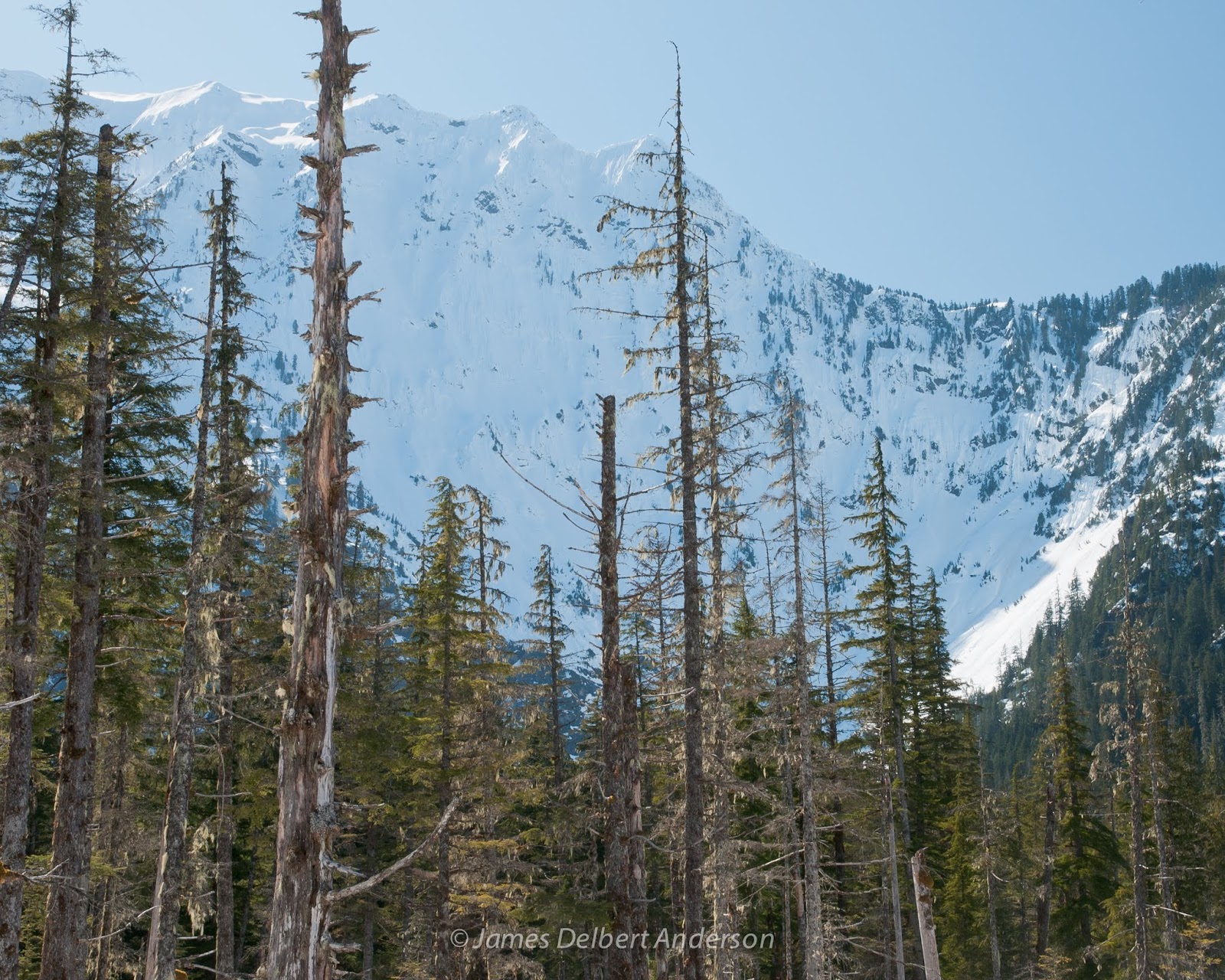
Next, a view of what I believe to be Hall Peak. One fun aspect of winter is the opening up of views like this; much less of the peak will be visible in the summer. F/14.


Finally, two more views of Big Four through trees. I think I like the horizontal one better, since it gives more of a sense of the terrain's contours. Both F/14.


That's all for today! Stay safe and healthy!

Monday, March 16, 2020

Skookum Flats

Many of you in the area probably experienced our little late-winter cold snap last weekend; some lowland locations (Enumclaw, for instance) even got a dusting of snow. This inspired me to seek out some snow to hike in and photograph. I found it at Skookum Flats, just off Highway 410. It's a lovely trail that mostly travels through old-growth forest, with opportunities to view the White River and the hillsides beyond.

First, a view of the White River (or, at least, a channel of it), which I accessed via a well-defined side trail. I liked the way the snow followed the contours of the rocks on the river banks. F/16.


Second, a composition contrasting the white of the snow with the rich ever-present colors of moss and evergreen trees. F/18.


Third, a wide view of the White River. There's no close foreground here, so this image isn't my best example of depth. But I like the sense of open space, and the blurred water in the lower third. F/16, 1/2 second.


Finally, a view through the forest. The foreground trees aren't quite as visually compelling as I had imagined them, but I like the sense of depth and scale. F/14.


A Mossy Shade of Winter

I don't think I'll ever get tired of the Baker River trail. I hiked there last Thursday, and enjoyed an exceptionally quiet and peaceful day gazing up at old-growth trees and listening to the river. It was a magical moment between winter and spring; the trail itself was mostly snow-covered, but many of the trees and shrubs were budding. A few ice pellet showers notwithstanding, I enjoyed excellent lighting and wind conditions for photography.

First, a sign of spring: the willows along the banks of the Baker River are starting to open up. At this point, I'm not sure what species this is. F/20.


Second, a mossy forest view, with bigleaf maple trees framing an old cedar tree. F/16.


Here's a view over the Baker River valley. This one barely worked; trying to get both the foreground trunk and the background in focus led to a compromise in image quality, and there was some glare from the filtered sunshine overhead. Nevertheless, it's just good enough to be usable. F/18.


Finally, a relatively close view of a bigleaf maple trunk, with licorice fern growing on it; the mossy branches of another bare bigleaf maple tree are visible in the background. F/8.


I'll be posting soon about another recent quiet forest adventure. Until then, take care and stay healthy! A lot of parks and trails, even here in western WA, are currently still open to the public, at least partially (visitor centers and indoor facilities are generally closed). We should definitely all take recommendations for social distancing very seriously, while remembering that there remain safe ways of getting outside and continuing to take care of our physical and spiritual well-being.

Saturday, March 07, 2020

Tursi Trail

For all the times I've visited Deception Pass State Park, this Thursday marked my first time hiking the Pass Lake and John Tursi trails. I enjoyed the diversity of plant communities throughout the hike; the trail alternates between lush alder and cedar forests, drier Douglas fir forests, and hillsides with grassy meadows and Pacific madrone (or madrona) trees. Although other parts of the park probably offer better opportunities for wildflower photography, the meadows here could be worth a return visit later in the spring; the forests definitely are.

First, an encouraging sign of spring: leaves of osoberry, or Indian plum (Oemleria cerasiformis) emerging. Sword ferns and red alder trunks are visible in the background. F/11.


Next, a forest view along the trail. I imagine this stretch of trail will be very lovely in late spring and early summer. F/14.


Next, a view into the Heilman Valley, with Pacific madrone or madrona (Arbutus menziesii) in the foreground. F/16.


Finally, a view across the Heilman Valley toward Rodger Bluff. The edit I'm posting here is a good start, but some additional color and contrast work, to further differentiate the foreground trees and background cliffs, will probably be in order. F/14.


In addition to the John Tursi Trail and Pass Lake loop, I also hiked the Big Cedar trail, which is not shown on maps but clearly signed. It's a steep grunt up a creek ravine, but it's always worthwhile to check out old-growth forest in western Washington (there are, indeed, a couple very large old cedars along the trail). I didn't get any pictures this time, but the area might be worth a return visit later in the year, when the understory is greener and has less visible detritus.

That's all for now, folks! Enjoy your day and wash your hands!

Tuesday, March 03, 2020

Late Winter along the Green River

One of the many things I love about living in western Washington is that the entire year is colorful. In the winter, evergreen trees, moss, rivers, and other elements combine with a typical lack of snow to create some surprisingly colorful photography opportunities. I had such an opportunity on Saturday, when I visited Kanaskat-Palmer State Park (near Enumclaw) during a few hours' break between morning rain and afternoon hailstorms. The trails feature numerous scenic views of the Green River, including rapids and calmer stretches.

First, two slightly different views of the same tree, with the Green River in the background. I am unsure which composition I prefer: the first is, I think, more balanced, with a slightly more attractive angle on the foreground tree. The second has more clearly distinct background elements (the rock at center and bright trunk at left). Both F/14, 0.6 seconds.


Here's another interesting shot of the river. I like the look of the water and the rocks beyond; I'm less thrilled by the background trees at the top. In my mind's eye, the moss- and lichen-covered branches were more visually prominent and easier to track. F/14, 1.3 seconds.


Finally, a a view of a calmer spot along the river, where the absence of rapids makes the water's color more clearly apparent. F/16, 4 seconds.


Monday, March 02, 2020

Something A Little Bit Different

This post represents a bit of a geographical departure from my standard fare. Roughly a week ago, I returned from a trip with my girlfriend to Grenada in the Caribbean. There's a lot to recommend it: It's a lush tropical island with friendly people and plenty of good food (including locally produced chocolate). People I talk to who are not familiar with the island are sometimes surprised to learn that its landscape is diverse, with variations in topography and precipitation. There is thus plenty of interesting scenery on offer.

The trip included a photography stop at Mount Carmel Falls, on the east side of the island. It's a tranquil spot and a worthwhile destination, if one doesn't mind navigating a bit of mud!

F/16, 0.5 seconds:


F/18, 0.8 seconds:


Other than my time at Mount Carmel Falls, I didn't get the big camera out; getting around with it on the island was challenging, and the trip was filled with a variety of other activities. I am thus taking the unusual step of including a few phone snapshots from around the island, to give a sampling of the landscape.

Looking roughly southwest, toward Grand Anse Beach:


The countryside of Saint Mark parish:


Looking roughly north toward St. George's:


Magazine Beach: